


La Ferte Milon le 26/09/2024

VANDERPUTTENMi
User GUIDE
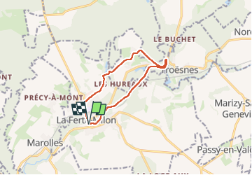

Length
9.3 km

Max alt
139 m

Uphill gradient
130 m
Km-Effort
11 km

Min alt
66 m

Downhill gradient
130 m
Boucle
Yes
Creation date :
2024-09-26 07:38:49.391
Updated on :
2024-09-26 15:11:02.005
2h30
Difficulty : Medium

FREE GPS app for hiking
 SityTrail
IGN / Geographical institutes
SityTrail Plus
The world is yours!
About
Trail Walking of 9.3 km to be discovered at Hauts-de-France, Aisne, La Ferté-Milon. This trail is proposed by VANDERPUTTENMi.
Photos


Positioning
Country:
France
Region :
Hauts-de-France
Department/Province :
Aisne
Municipality :
La Ferté-Milon
Location:
Unknown
Start:(Dec)
Start:(UTM)
509194 ; 5447052 (31U) N.
Comments